Covered Bridges

Covered Bridges of Oregon

What is a "World Guide Number?"

Local naming of covered bridges can prove to be inconsistent, and many bridges have more than one name.

Each bridge in this section has a unique identification called a World Guide Number. This system of identifying covered bridges on a national scale was developed in the 1950s and has been adopted by the National Society for the Preservation of Covered Bridges.

The assigned World Guide Number for each bridge is the combination of a state, county and bridge identifier.

Oregon, being the 37th state alphabetically, dictates the first two digits of the identifier.

The counties are also assigned numbers in alphabetical order. All bridges in Benton County, for example, contain the number 37-02- because Benton County is the second county in the state alphabetically.

The third set of numbers are assigned to the actual bridge location, although the name of the bridge or stream is not a factor in the assignment. Many bridges have been destroyed since the adoption of the World Guide Number. Since the number is not reused or reassigned, some numbers are missing.

Combinations of numbers and letters denote a bridge which does not use a true truss for support but is covered nonetheless.

Earnest Covered Bridge
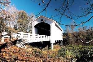
Earnest Bridge over the Mohawk River in Lane County is World Guide No. 37-20-35

Information included in this section was provided by Bill Cockrell, who with his brother Nick authored "Roofs Over Rivers" and is presented here in cooperation with the Covered Bridge Society of Oregon.

South Myrtle Creek (Neal Lane) Covered Bridge

Location:
From the city center of Myrtle Creek travel south on Main Street to Riverside Drive. Head east on Riverside Drive to Day's Creek Cut Off Road. Travel South on Day's Creek Cut-off Road to Neal Lane.

Background:
The Neal Lane Bridge near the town of Myrtle Creek has at least two distinctions: it is one of the shortest covered bridges in Oregon, and the only roofed span in Oregon using a kingpost truss design.

The wooden bridge is just 42 feet long, and the addition of the narrow windows make it appear even shorter.

South Umpqua River (Milo Academy) Covered Bridge

Location:
From Canyonville travel east on Third Street and continue through Days Creek to the community of Milo. The bridge is located east of Milo at Milepost 20.5

Background:
The bridge at the Seventh Day Adventist Academy near Milo is one-of-a-kind in Oregon covered bridge history. The covering certainly is not a structural necessity but fills an aesthetic need, as it is Oregon's only steel bridge housed in wood.

The World Guide Number now ends with a letter, indicating the span is not a true truss supported bridge.

Swalley Canal (Rock O' The Range) Covered Bridge

Location: 

Travel two miles north of Bend on Highway 97 toward Redmond. The bridge is located on Bowery Lane, west of Highway 97.

Background:
Rock O' The Range is Oregon's only covered span located east of the Cascade Range and one of the few covered bridges built in the last two decades for private use.

It represents an architectural style unique to Oregon.

Thomas Creek (Gilkey) Covered Bridge

Location:
From Interstate 5 exit 238 and travel east to Jefferson. Just east of the arch bridge over the Santiam River, turn right on South Main Street and continue until the street turns into Jefferson-Scio Drive. Continue east towards Scio and turn right (south) onto Robinson Drive. As Robinson Drive curves east, turn right on Goar Road and travel 1.5 miles to the bridge. Alternately, travel one-half mile south of Scio on Highway 226, then three miles west on Gilkey Road. Turn north on Goar Road and travel 0.5 mile to the bridge.

Thomas Creek (Hannah) Covered Bridge

Location:
From Interstate 5, exit 238 and travel east to Jefferson. Just east of the arch bridge over the Santiam River, turn right on South Main Street and continue until the street becomes Jefferson-Scio Drive. Continue east into Scio and turn left onto Highway 226. Follow Highway 226 approximately six miles west to Camp Morrison Drive and turn right (south). Alternately, exit Highway 226 from Interstate 5 in Albany and travel to Scio.

Thomas Creek (Shimanek) Covered Bridge

Location:
From Interstate 5 exit 238 and travel east to Jefferson. Just east of the arch bridge over the Santiam River, turn right on South Main Street and continue until the street becomes Jefferson-Scio Drive. Continue east into Scio and turn left onto Highway 226. Follow Highway 226 two miles east and turn left (north) onto Richardson Gap Road.

Background:
As Linn County's newest and longest covered span, the Shimanek Bridge offers an exception to the usual open-sided structure with rounded portals.

Wildcat Creek (Austa) Covered Bridge

Location:
Travel 33 miles west of Eugene on Oregon Highway 126 to Whitaker Creek /Clay Creek Recreation Area turnoff. Exit the highway on the south side and follow the road back under the highway and railroad tracks (north) a short distance to the bridge.

Background:
The Wildcat Bridge is located on a small winding road a short distance from Highway 126.

From the bridge site where Wildcat Creek flows into the Siuslaw River, Stagecoach Road hugs the hillside until it drops into the narrow plain at Swisshome.

Yaquina River (Chitwood) Covered Bridge

Location:
From Interstate 5, take the Corvallis exit (228) west 38 miles through Philomath on US 20. The bridge adjoins Highway 20 near milepost 17. Alternately, travel east from Newport on Highway 20, 17 miles to Chitwood.

Background:
Not much activity occurs at Chitwood anymore. The Chitwood Bridge was once surrounded by several stores, a post office, a telephone office, and several houses. The boarded up remains of the Smith store nearby is a dim reminder of the vitality the community once had.

Subscribe to Covered Bridges