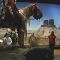
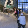
It’s one thing to read about history in a book, or see a movie, but it’s quite another to see, feel and walk through the history of a people from their unfiltered point of view.
Attractions: Sightseeing
It’s easy, driving along in your car, to completely miss the Western experience that is Pendleton.
City: Pendleton
Region: Eastern Oregon

Length: 106 miles / 169.6 km
Time to Allow: 5-7 hours
Fees: A few museums charge fees. So do some campgrounds.
Region: Eastern Oregon

Length: 218.43 miles / 349.5 km
Time to Allow: Allow about 8 hours to tour this Byway.
Region: Eastern Oregon
Hiking, history and heritage, that’s the theme of the Oregon Trial Interpretive Center just East of Baker City.
City: Baker City
Region: Eastern Oregon
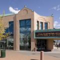
The Craterian Ginger Rogers Theater is southern Oregon's state-of-the-art community performing arts center. The facility features excellent acoustics and sightlines, an impressive array of theatrical equipment and is operated by a professional staff. The auditorium is intimate and comfortable and seats just 732 patrons, yet the stage can accommodate large national concert, dance and theatrical tours.
City: Medford
Region: Southern Oregon

The chocolate store, located on Highway 99, or North Front Street in Central Point, opened its current location a few years ago to take advantage of what business owners in the area call an “artisan grouping.” Lillie Belle is located next to Rogue Creamery (who built the building for him) and it has big windows where you can watch Shepherd make his confections.
City: Eagle Point
Region: Southern Oregon
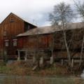
The Butte Creek Mill and General Store is still one of Southern Oregon’s favorite destinations today as people come to take home the whole grain goodness of mills flours baking mixes and many culinary treats along with a whole lot of history. The mill began operation in 1872, built by the pioneers with double-bitted axes and hand saws felled trees that were already more than one hundred years old.
City: Eagle Point
Region: Southern Oregon