We offer one private room and three dorm rooms.
Regions: Greater Portland
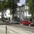
AAE Hostels has 2 locations in Portland. Offering Private Ensuite Rooms at discounted backpacker rates.
City: Portland
This grove of western red cedars was planted in 1934, the first of hundreds of tree plantings organized by Lockyear in a life dedicated to reforestation.

The original start of this lilac was brought from Maine to Oregon in 1843 by Mary Charlotte Foster, wife of Philip Foster, partner with Sam Barlow on the Barlow Road.
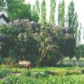
The original start of this lilac was brought from Maine to Oregon in 1843 by Mary Charlotte Foster, wife of Philip Foster, partner with Sam Barlow on the Barlow Road.
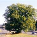
This bigleaf maple is believed to have been a meeting place for local Native Americans since time immemorial, leading to its traditional name.

Although it is now known that Dawn Redwoods graced the landscape of the world's northern temperate regions during the time of the dinosaurs (Late Cretateous), fossils of this species were first discovered in 1941 in J
City: Portland
The Nyberg Chestnut was part of a 150 tree mixed orchard that was planted around 1903 and owned by John Nyberg, a immigrant from Sweden.
James Withycombe served as Oregon's governor from 1914 until his death in 1919. He was one of only two foreign-born Oregon governors.
City: Hillsboro

The majestic trees that grace the grounds of the Washington County Courthouse were planted in 1880 as three year old seedlings by pioneer nurseryman John R. Porter.
City: Hillsboro