Length: 286 miles / 457.6 km
Driving Directions
Attractions: Byways-Routes
Length: 45 miles / 72.0 km
Time to Allow: 1-2 hours minimum.
Fees: No fees known.
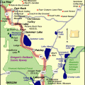
Region: Southern Oregon
Length: 68 miles / 108.8 km
Fees: There are fees associated with parking for more than a few hours near trailhead markers. Also, permits are required.
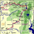
Region: Southern Oregon
Length: 140 miles / 224.0 km
Time to Allow: Plan for 5 to 7 hours to tour this byway.
Fees: There is a fee to enter Crater Lake National Park.
Region: Southern Oregon
Length: 172 miles / 275.2 km
Time to Allow: Plan on 7 to 8 hours to tour this Byway.
Region: Southern Oregon
Length: 171 miles / 273.6 km
Time to Allow: Expect 3 to 4 hours to experience all this Byway has to offer.
Region: Southern Oregon
Length: 70 miles / 112.0 km
Time to Allow: Allow 3 to 5 hours minimum. However, many travelers take a few days to experience all the sights.
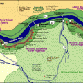
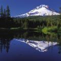
Region: Mt. Hood/Columbia Gorge
Length: 55 miles / 88.0 km
Time to Allow: 90 mins, minimum. All day is reccommended.
Fees: Some state park and attractions charge fees.
Region: Willamette Valley
Length: 80 miles / 128.0 km
Time to Allow: 4 to 5 hours
Fees: Some fees may be charged at some attractions.
Region: Eastern Oregon