
At K-Bar Steak House, they know their steaks.
Regions: Southern Oregon
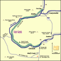
Length: 45 miles / 72.0 km
Time to Allow: 1-2 hours minimum.
Fees: No fees known.
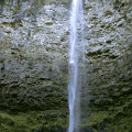
Your journey through the Umpqua River Basin starts with 10 waterfalls with a variety of picnic areas and hikes. There's something here for all skills and abilities.
Rusk Ranch Nature Center is a nonprofit organization in Cave Junction, Oregon with a mission to promote the wellbeing of the residents of our community and conserve nature.
City: Cave Junction
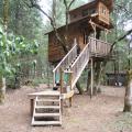
The Out N' About Treehouse's located near Cave Junction, offer more than a step up from traditional camping with their four star Treesort lodging as well as onsite activities such as horseback riding, zip line rides, art classes and full service spa.
City: Cave Junction
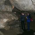
Tour interpretor Julie Anderson says the caves are 3 million to 5 million years old. Each person who visit finds something special.
City: Cave Junction
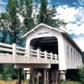
The Grave Creek covered span at Sunny Valley, about 15 miles north of Grants Pass, can be seen by motorists traveling Interstate 5.
City: Grants Pass
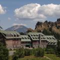
Truly a grand northwest lodge, the historic 71-room Crater Lake Lodge originally opened in 1915 and is located on the edge of the caldera overlooking Crater Lake. The lodge was reopened after extensive renovation in 1995 and offers an atmosphere reminiscent of the 1920s and immerses visitors in its rustic charm.
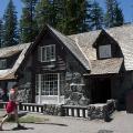
The Steel Visitor Center is at the Crater Lake National Park headquarters and offers a 18-minute film, free advice about how best to enjoy Crater Lake, and has a post office.
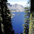
Few places on earth command overwhelming awe from observers, but Crater Lake, in south central Oregon, certainly does. Even in a region of volcanic wonders, Crater Lake can only be described in superlatives. Stories of the deep blue lake can never prepare visitors for their first breathtaking look from the brink of this 6 mile wide caldera which was created by the eruption and collapse of Mt. Mazama almost 7,000 years ago.